Shé:kon Sewakwé:kon, hello, everyone! I want to make a catch-up post. Hopefully, I can start posting regularly about my work on this blog again.
Know History
I have been busy since starting with Know History in May 2019. During that time, I created a short documentary film, Bridging the Past, exploring the Quebec Bridge Disaster of 1907 and its impacts on Kahnawá:ke. One of my great grandfathers, Thomas Jocks and his brother Louis Jocks, died on the Quebec Bridge. I spoke with Kahnawa’kehró:non about the memorial in the community, then interviewed Cathy and David Rice about the legacy of the Quebec Bridge in town.
I also started work on an oral history project with Gerald Taiaiake Alfred and Trina Diabo in Kahnawá:ke that collected stories from community elders on various topics. Focusing on life before the Seaway and up until the 1990 resistance, we spoke with over 40 elders in the community. I was so thankful to learn from the elders and Taiaiake and Trina. It was a privilege to listen to stories of old Kahnawá:ke and meet elders who knew my relatives.
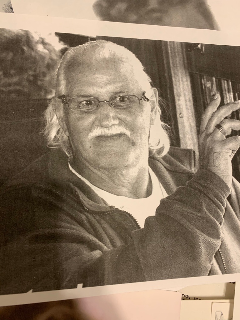
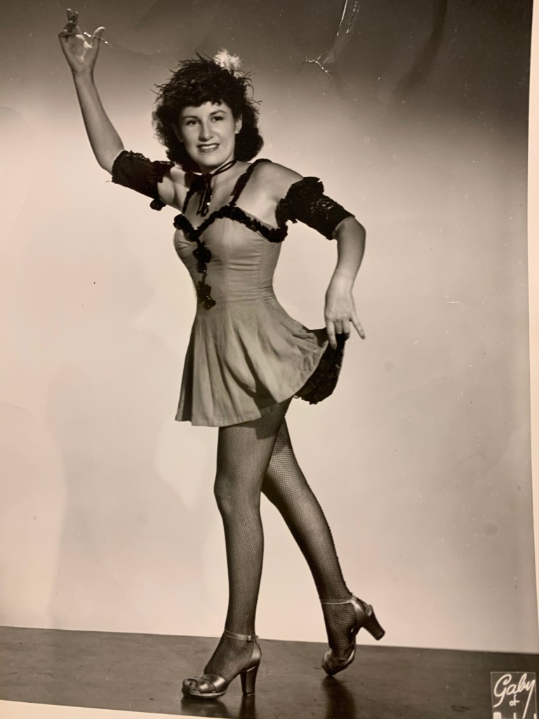
This project also gave me the opportunity to get closer to my family. I stayed with my cousin Jo-Ann Stacey and my dad, Mike Stacey, stayed with us while I was in the community for the summer and early winter of 2021. I saw some of my dad’s Kahnawá:ke league baseball games and went through old family photos. I learned so much about my grandparents and their involvement in New York ironwork, the Radio City Rockettes, and the Montreal and New York jazz scenes. My great-grandfather Frank Stacey was an ironworker and a jazz musician who played drums and piano. His sister Marie was a Rockette who moved to Monaco and Panama to perform before settling in Nevada.
Frank, during his ironwork days in New YorkMy grandfather Allen “Tiny” StaceyMy grandfather Frank (middle) is on percussionFrank (center) on pianoMy aunt Marie StaceyMarie Stacey
After my role on the oral history project wrapped and Know History proceeded further on the editing work, I have contributed to research projects that took me into Library and Archives Canada, the Canadian War Museum research centre, and the collections of the Canadian Museum of History. I am most proud of the work with the Survivors Secretariat.
Presentations, Conferences, Talks
Since leaving Western in April 2019, I have done a variety of talks and presentations as an invited guest and at conferences.
Displaced attacks on our existence:” Changing Public History Practice to Support Kanien’kehá:ka history in Tiohtià:ke. Canadian Historical Association Annual Meeting, Online. May 18, 2022. As part of Haudenosaunee Responses to and Engagements with the field of Public Historywith Cody Groat, Heather George, and Dr. Talena Atfield.
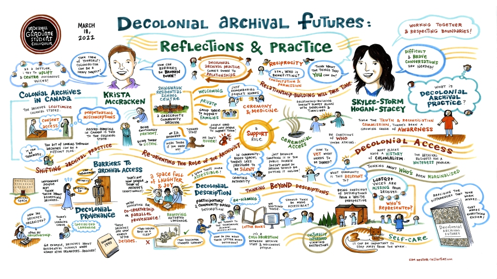
Decolonial Archival Futures. Keynote Presentation for the Underhill Graduate Colloquium, Carleton University. March 18, 2022, with Krista McCracken.
More than a Rewrite: Challenging Commemoration and Public History Practice. SRSC Webinar Series, February 15, 2022.
Archives as Healing, The Shingwauk Residential Schools Centre for the Trauma-Informed Archives Community of Practice Meeting, Indian Residential School History and Dialogue Centre, University of British Columbia. November 9, 2021.
Community First: Open Practices and Indigenous Knowledgewith Krista McCracken forthe Comparative International Education Society Conference. April 26, 2021.
Bridging Connections: Indigenous Stories and Finding Community. National Council for Public History Conference. March 2021.
Navigating Archival Access and Care; An Indigenous Researcher’s Perspective. Archives of Ontario, Access + Care Indigenous Knowledges Symposium. October 23, 2019.
For our keynote talk last spring, visual recorder Sam Hester made an amazing representation of Krista and me!
Krista and I have collaborated on several projects since I started working with them in 2015. Their friendship and mentorship have provided so much growth during my academic and professional career. I am also grateful to my family and community mentors, who have provided guidance and insight as things progress.
Forthcoming Book!!
In 2020 Krista McCracken and I began writing a book together! Decolonial Archival Futuresis now in the final stages of copy editing and will hopefully arrive in late 2023.
Recent Review!
I recently published a film review in Archivaria, the journal of the Association of Canadian Archivists. In this review, I discuss the 2020 film Beans, directed by Tracey Deer, and her use of archival footage. In addition to the film, I look at how archivists can support Indigenous creators and communities through reimagining provenance. Please reach out if you would like a PDF copy of the article!
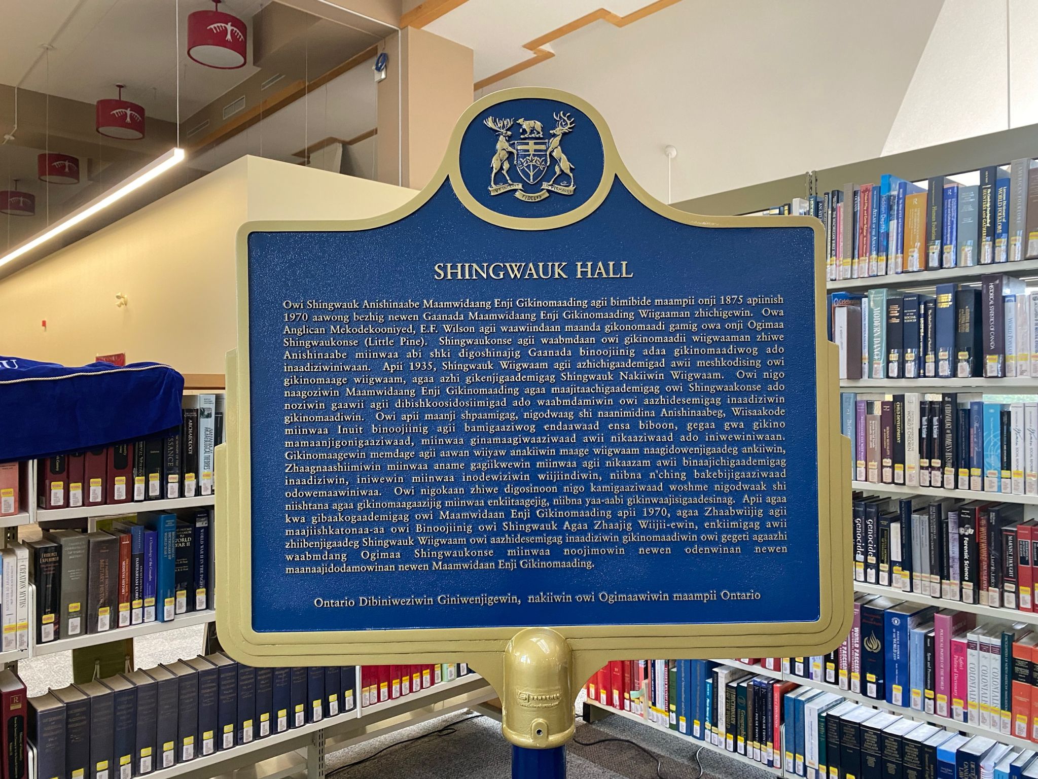
Ontario Heritage Trust Plaque
In 2022 I was commissioned to research and rewrite the Shingwauk Hall Ontario Heritage plaque. I worked with the Children of Shingwauk Alumni Association and the Shingwaulk Residential Schools Centre to deliver a final text that communicated the significance of the site but also the important legacy of healing that it now represents. I also completed media resource research and wrote a new provincial plaque historical background for Shingwauk Hall.
The finished plaques appeared in Anishinaabemowin, Swampy Cree, English, and French.
New Opportunities
I am starting an interchange with the Office of the Independent Special Interlocutor for Missing Children and Unmarked Graves and Burial Sites associated with Indian Residential Schools. I will be away from Know History until 2024 and assisting the Research and Legal Department of OSI-BIS with historical and policy research as they fulfill their mandate. I am excited to use my skills in archival research, literature and policy review, cybercartography, site history writing, and report writing to support this important work. I am also honoured to have the opportunity to learn from a strong team with diverse skill sets. This will be a challenging but vital experience for growth and building skills to give back to the communities that have supported me so much.
I hope I can also assist with my knowledge of commemoration and Indigenous community-based archival frameworks.
There is much more I am excited about in 2023, and I look forward to keeping up with this blog and sharing my public history adventures. Niá:wen, thank you for reading this long catch-up post!
I’m now a Research Assistant at the Museum of Ontario Archaeology
Where the magic happens.
What will I be doing there? Probably a few different things.
The collections at the Museum of Ontario Archaeology (MOA) are many, and not all of that information is stored in one place. The museum was once known as the Museum of Indian Archaeology (which made me super uncomfortable once I found out) and the collections definitely feel focused on that history. As an RA I have been tasked with a few different projects that will develop a new focus for Sustainable Archaeology, which is now a set of practices and theories rather than a physical space. I have also been asked to create some digital interactivity with their current collections.
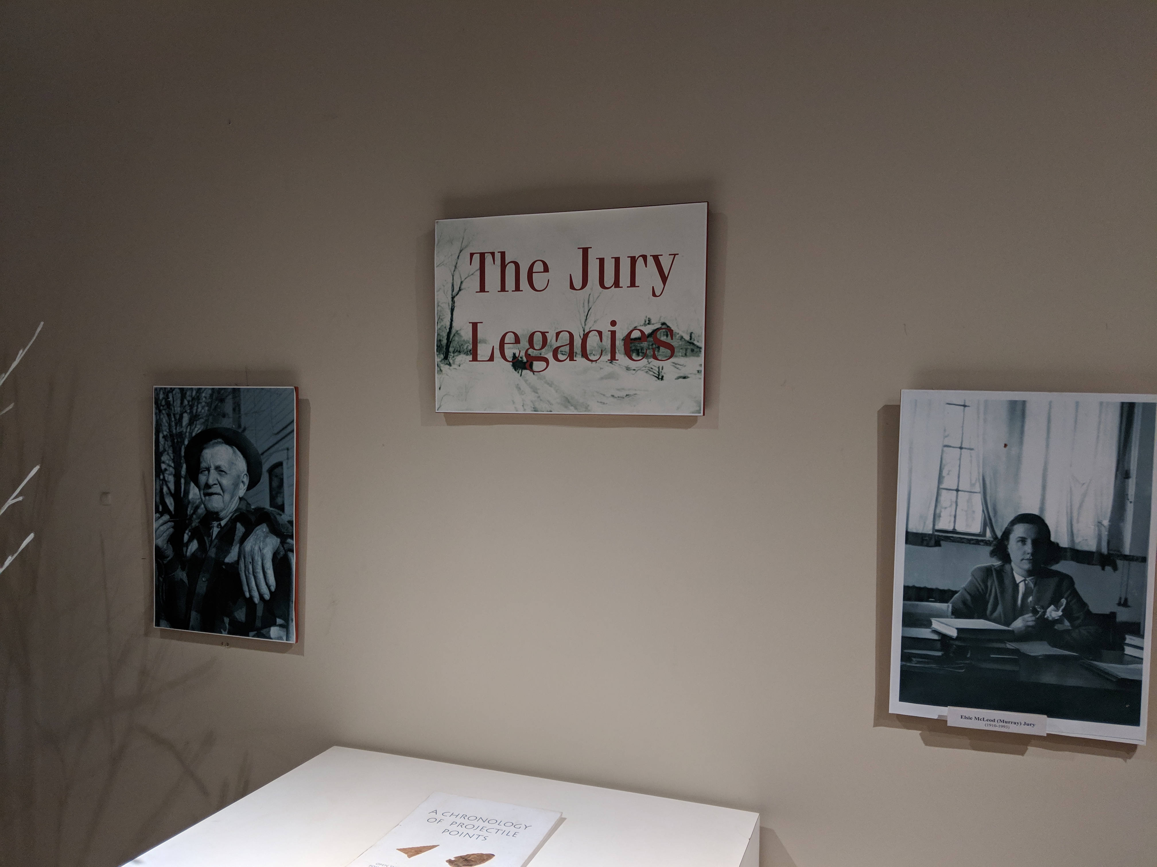
The museum was founded out of the University of Western Ontario (UWO) and their main legacy collection was formed by Wilfrid Jury. The museum has recently changed its focus from looking at the collecting, work and life of the Jury’s to the history of the field of Archaeology itself. With these things in mind I began trying to find ways in which I could build an interactive Story Map exhibit for the MOA’s use.
Looking at the amount of material available on Wilfrid Jury, my first thought was to start with those collections. The MOA wants to change some of the narratives they used to focus on but I think it’s important to work with what you have the most of. Jury can be valuable although his language, motivations, and understandings of what the mission of history/archaeology should be are dated and problematic. From what I have read so far, Jury seems to have been passionate about preserving the physical past and understanding the ways in which early settlement and the early formation of Canada occurred. Jury had fascination with ‘Pioneering’ and settlement, in-line with many Canadians of the time. Most of the sites were from early settlement, from the late 1600’s on and had both European and Indigenous inhabitants.
Attawandaron village model built by Wilfrid Jury and his father Amos
Attawandaron village model built by Wilfrid Jury and his father Amos
Attawandaron village model built by Wilfrid Jury and his father Amos
Attawandaron village model built by Wilfrid Jury and his father Amos
Attawandaron village model built by Wilfrid Jury and his father Amos
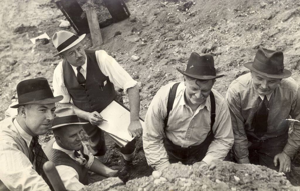
Wilfrid Jury had been an amateur collector with his father, an eloquent way to say that they went to ‘ancient Indian’ territories to dig stuff up. This was something the middle and upper classes from colonial backgrounds did frequently across the globe. I learned while visiting the Oil Springs museum in Lambton County that turn of the century ‘Canadians’ were heavily involved in resource exploitation and ‘collecting’ artifacts from various places around the world. Many who are focused solely in the fields of Archaeology or Museology know that many of the institutions we have today were started at viewing rooms of large collections of these ‘well-traveled’ men.
Oils Springs is a giant colonial curiosity cabinet
You should be able to tell what is wrong with this
You should be able to tell what is wrong with this
This thing made me feel physically sick, glorifying my nightmares.
Curiosity cabinet display at the MOA
Curiosity cabinet display at the MOA
The beginnings of the MOA were no different, Wilfrid Jury had a need to store his massive collection somewhere. Jury’s relationship as an Archaeology professor at UWO and the Lawson site provided the opportunity to convert that site into the Museum of Indian Archaeology, later the Museum of Indian Archaeology and Pioneer Life, then the Museum of London Archaeology, and finally the Museum of Ontario Archaeology as it is today. Even this change of names is representative of the contemporary work being done to distance institutions from the legacies of ‘collecting’. Deaccessioning problematic collections and returning them to their proper places, collections management policies, database description language- all ways in which these institutions are attempting to open up narratives.
The exhibition space at the MOA has been undergoing changes that reflect this desire to change the narratives of their problematic past. Aside from some of the problematic depictions of pan-Indigenous peoples that remain in the space, some of the transition has already begun. Once there was a replica of Wilfrid Jury’s office, as well as several collection cabinet drawers that talked specifically about that legacy and how Jury transformed from a hobbyist into a professional archaeologist. There have also been updates to the signage around the exhibition space, talking about how this type of heritage work is contested.
This slideshow requires JavaScript.
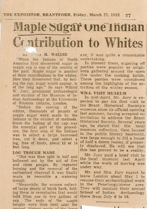
Apparently Maple Sugar was OUR ONE CONTRIBUTION TO WHITES. This was allowed to be printed.
Researching this legacy and the way in which Wilfrid rose to the position he held has been a testament to the times. It brought to mind for me the legacy of E.F. Wilson and my work at the Shingwauk site. Wilfrid Jury was a professor of Archaeology at the University of Western Ontario, started the first Archaeology field school in Canada, and had started the Museum of Indian Archaeology at UWO. Working from a background in Residential Schools history and community archival practice, I have to retool my processes to be less forthcoming about my ‘biases’ on colonial power structures and subverted racism. This being a larger institution than the Shingwauk Residential Schools Centre with a mandate that doesn’t exclusively serve the Indigenous communities around it, I know I will have to be cautious about what I say and that whatever I do say will be edited by 10 other people who may not be from this particular background.
I think it is valuable to talk about these dynamics when creating an exhibit. The MOA is currently working from a set of best practices informed by the Sustainable Archaeology program, something vastly different from the Jury days. The Jury journals have language in them that is dated, it has been redacted in some of the previous student assistant blogs but I think it is important to talk about the fact professionals and ‘experts’ called us savages and that was accepted as an academic truth. I think it is important for museums to show growth, even when that calls attention to a problematic past.
This slideshow requires JavaScript.
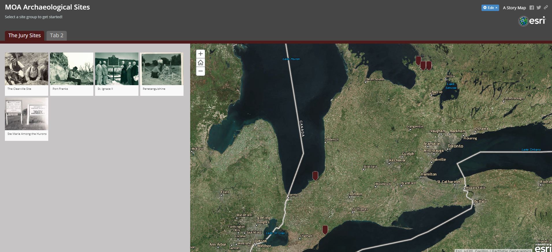
The exhibit medium I chose for my first project is Story Maps because of my recent experiences using it. I want to gain more experience with the medium but I also feel that this lends itself well to the large smart screen that is available on the museum exhibition floor. I have two maps in mind for my work, one looking at Wilfrid Jury and the legacy of Archaeology as a practice and the other looking at the locations the MOA collections come from. The Jury focused map will be in the form of a Story Map Journal and the other Story Map will be in the Shortlist format.
The Jury focused Story Map research is based off of the massive collection held at the MOA which includes his handwritten journals as well as field reports. I am hoping to put these sites in chronological order supported by Jury’s journal entries and some field reports for the information on the site itself. To make the connection between what was archaeological practice then and how we critically examine those practices now is something I’m still figuring out. But I think that once the journal takes shape, and it has been reviewed by the Museum director I can start to make those connections in the way the Museum needs.
Shortlist format StoryMap
This map will be large and less detailed than the map I have planned for Jury. This map’s purpose is to be a quick information base on the MOA collections and to give every day visitors an idea of how large everything is behind the scenes. The Shortlist format lays out tabs and within those tabs are individual pins that can be tied to a location with an image and some background text. Depending on which tab is selected it will display what pins are within that tab on the overall map. I chose this layout because I think it would lend itself well to the large smartboard on the exhibition floor. It also does well at breaking up the archaeological sites into categories. If the sites were all displayed at once the map would feel overwhelmed, even if each pin was a different colour. Looking at the number of sites the collections originate from, I wouldn’t have enough colours to differentiate them well enough.
The Shortlist view allows the user to click either directly in the tab menu or click the individual pins on the map. Which provides more accessibility on a large touch-screen. I have been directed to the MOA’s large archaeological library to begin to gather data on sites. For each location pin I would like it to be the approximate site with any relevant field data that can be educationally or contextually helpful (types of artifacts recovered, why the work was done, photographs of either the site or artifacts). I anticipate some challenges in finding digital materials to accompany the site pins. In some cases I might have to just type in the location data, which can be boring to younger audiences.
The value of this Shortlist map is in showcasing the numerous origins of the Museum’s collection, the diversity of the collection, in explaining why excavations begin, and showing how close archaeological sites are to urban life. For many students who visit the museum, they do not understand that artifacts are regularly recovered from unlikely places. Many of us think of urban areas as never having a legacy of Indigenous use but this is simply untrue. Many of the sites we select for suburban villages are the same sites that Indigenous peoples chose. The remains of old villages lie just beneath the surface in rural and northern areas, religious missions long abandoned or resource boom-towns left ghost when industry dried up.
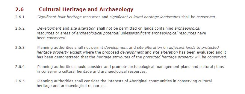
With all this heritage buried throughout Ontario, you think there would be a vested governmental interest in what is found there. However there is surprisingly very little protection for what is recovered from excavation sites. The Ontario Provincial government has proposed a new plan that will make development ‘easier’ in Ontario by allowing municipalities to skip some of the protections outlined in the Planning Act, the Clean Water Act, and the Greenbelt Act. Many have heard about Bill 66 from environmentalists concerned with Greenbelt development and the lack of protections on drinking water, the ominous Section 10. The archaeological community is concerned with what some of these provisions mean for protected heritage sites and development on Indigenous sacred sites because they remove section 3(5) of the Planning Act that gives power to the Provincial Policy Statement (2014).
Archaeologists and developers work from a Provincial Policy Statement that broadly outlines the minimum standards for this work in Ontario. The PPS outlines what should be done in these processes. It doesn’t specify what should be in a plan to make it ethical, sustainable or ecologically safe; it just requires that you have a plan. I assume that plan has to be approved by the Minister for Housing and Development, or a Municipal planning office in accordance with that Policy Statement. Hopefully those people care more about health, safety, food sustainability, and heritage more than money. Unfortunately we know that for the majority who are interested in development or resource extraction, they are mostly concerned with money.
Section 10 of the proposed Bill 66 makes Archaeologists just as nervous as Environmentalists. Fortunately, because of the outcry surrounding the possibility of Greenbelt development this proposed legislation is being pulled by the Provincial government. It is disturbing that this Bill passed the first read, I’m sure a new version of this will be back within the year that specifically ensures the safety of the Greenbelt (to keep voters happy). If you want to know more about the position of the professional Archaeological community on these proposed changes made by Bill 66 check out this Timmins Martelle Heritage Consultants Inc. blog post.
There’s more!
This is where the other part of my RA-ship with the MOA comes in. I will be helping with the development of a new collections storage program at the MOA that uses the best-practices for conservation and ethical management from the Sustainable Archaeology project. Because there is little incentive for those who have artifacts in their collection to store them somewhere safe (not a random storage locker/shipping container) I have been tasked with coming up with some ideas on ways in which the museum can do that.
The MOA had done some research with a consultant on how to make this collections storage a sustainable program that relies very little on grant or government funding. However, it means presenting the benefits for storage costs and finding the quantity of clients needed to keep the program running. The more developers, archaeologists, survey companies, and resource extractors that decide to store with the MOA the more it can support those who need safe storage but do not have the resources.
Collections Storage at the MOA would see artifacts brought in, processed to Sustainable Archaeology standards (boxing and preservation steps), then the client could have these objects digitally processed. The implications this has for Indigenous communities pursuing repatriation efforts is substantial. Because many heritage institutions will not grant communities their ancestral property without a conservation/preservation plan, First Nations are often left with little options. Collections Storage at the MOA is looking to have very clear holdings and collections agreements, these could be set to community’s needs and expectations, including clarity on their ownership.
Working at the Algoma University Archives, there were artifacts being stored there that were not a part of the collection. They were from Missanabie Cree First Nation and the community needed climate controlled storage to preserve what they had. Collections Storage at the MOA has the future potential to provide these services plus more. The use of the digital lab opens up opportunities for the artifacts to be recreated digitally through 3D scan or with a 3D printer. While communities build their infrastructure to support their own museums, libraries and heritage centres Collections Storage can digitize artifacts to make available to the community for teachings and research.
The MOA’s relationships with the local Indigenous communities mean that their policy is informed by members of that board from these territories. Items can be stored in-line with cultural protocols if the community provides a request or a planned ceremony. I also suspect that as the museum gets more involvement from Indigenous clients that their policy will transform as needs present themselves.
The current MOA web site needs to reflect the new changes that have taken place between the institution and the Sustainable Archaeology program, this was another area of interest my supervisor was having me look at. Because of my recent experience in both Digital Research Methods and Digital Public History, I have had some experience now with web development and content generation using WordPress as a medium to host some of that content. The museum currently uses WordPress and I’ve been told at some point I will be working with that site. However I haven’t tackled this yet because there are so many eyes that this content needs to be read by and there is not yet a consensus on what this new program should be.
I’m looking forward to the next few months of work and how I will see the institution change during this time. I will be updating my blog when I can, I will be blogging more about Museums and associated structures and I move through ‘the machine.’
As the semester comes to an end I find myself looking through the Wolfram knowledgebase, trying to use features that I feel are neat or interesting. I want to be able to find a way to make the software enhance my research abilities, and through many of the lessons I have seen small snippets of what Wolfram Mathematica can help me do. The last classes focused on photo image processing which always peaks an interest of a public historian. Images are universal, a great way to tell stories across many lines, they are fun for the public to interact with, and can be easily digitized. Maps are similarly gifted with the ability to tell stories. I recently completed a project using Story Maps and realized I could do more using Mathematica. Even if I can’t make a ‘story map’ yet using these tools, I can easily create my own map images or complete research for my Story Map in GIS.
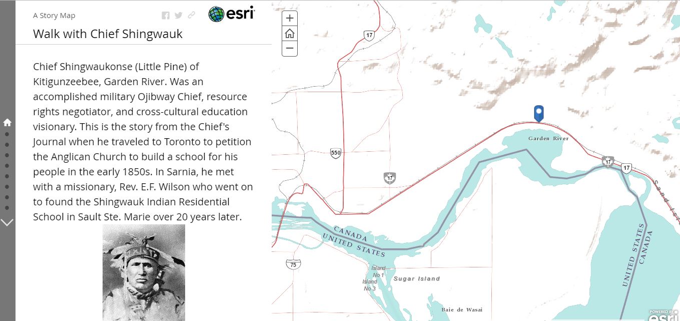
My recent Digital Public History project had me working on a Story Map version of the journal Chief Shingwaukonse, from Baawating (Sault Ste. Marie, ON). He made a journey from his home to Toronto in the 1850’s to petition for funds to give his young people a schoolhouse and teacher. A decorated veteran of 1812, a treaty negotiator, and spiritual leader, Shingwauk’s archives are regularly accessed. However, there is only a typed copy of his journal, I thought it could be more engaging for younger people, or those who wanted to see the journey, the chance to go on the journey with him. I got curious after our class on Maps on how I could blend these mediums together to make my project better. (Blog about this project here)
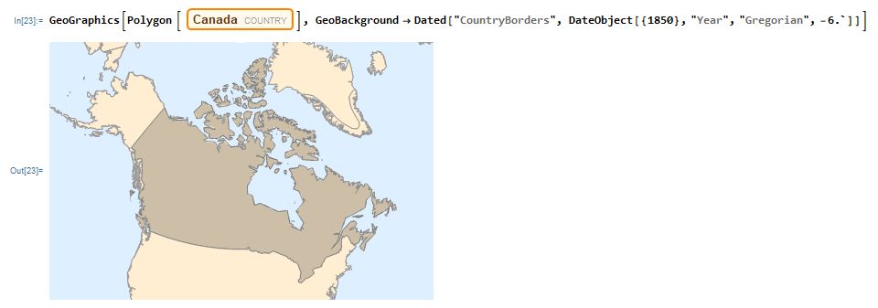
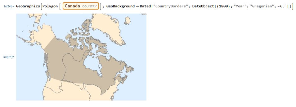
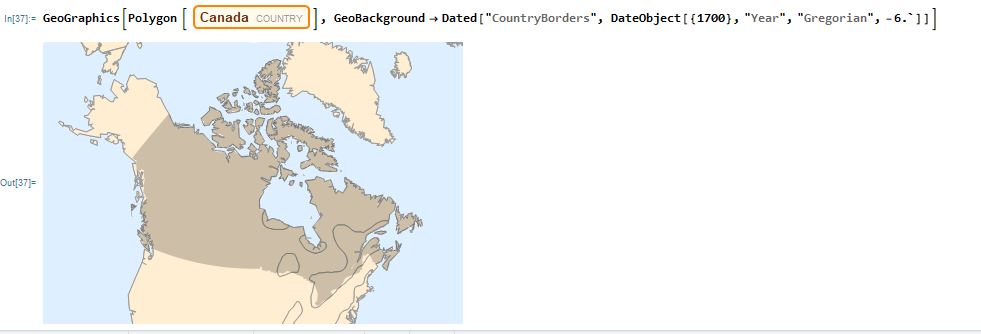
I began to play around with maps of Canada. Why? For myself, maps can be reminders of settler-colonial occupation and they can be tools for digital storytelling and cultural knowledge sharing. I found an interesting feature that allowed me to see established settler borders at earlier stages in history, within their current state. It was interesting to compare.
I started with 1850, the time of my project and a short time before confederation. The borders are not much different than they are at present day. However, if I go back further to 1700 there is less settler-occupied space. It was neat to play with.
Another interesting feature I looked at was a layer that shows more land details. This could be applied when talking about traditional land uses, climate migration, or relationships to geographic landmarks.
I kept the border highlight to emphasize Canada, but when looking at the land details it really demonstrates how something whole was sectioned.
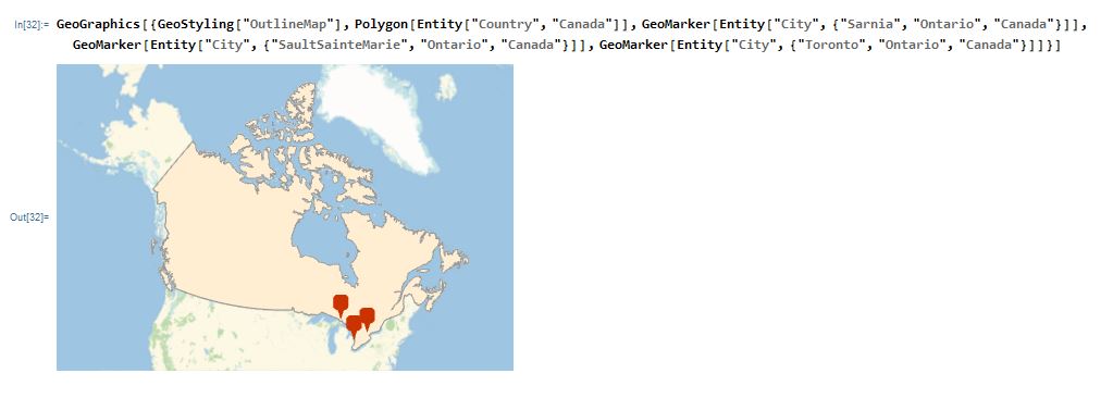
Wolfram Mathematica allows you to drop geomarker pins on your map. This is a similar styling to what was used in Story Maps. There is capability to fully customize the look of your pins and add pop-up tools and mouse-over tools, but I haven’t been able to use them effectively yet.
On this map I dropped plots for a few of Shingwauk’s stops; Sault Ste. Marie, Sarnia, and Toronto. Even if I can only make something marginally interactive right now, I can always use the Wolfram Alpha knowledgebase to do research for my Story Maps or Processing designed maps.
As it is a US-based knowledgebase I expected some of the smaller Northern Ontario towns not to have data. This can be easily rectified with Google, but it was neat to try it in Mathematica and see how I can use it for research.
How I Hope to Use My Skills- All the Possibilities Batman!
I hope to work in historical research consulting, or work to optimize collections for digitization. I feel like my small introduction to Wolfram Mathematica will help me in both of these endeavors. With historical research consulting I can use these tools to prepare and organize my research. I can create my own search tools and functions that will save me search and writing time in the future. I can even create research area specific RSS feeds to keep me up to date on my interests, or that of the client’s. I can pull from Alpha, then organize biographical and legal information to help prepare client reports. I can create visual tools like charts, graphs, maps, and word clouds to illustrate research data in ways everyone can understand.
If I’m interested more in image digitization, I can use Mathematica tools to help me provide researchers with the best information on images. I can pull several artworks from the same artist, analyze and compare their colour use, or layer them on top of one another to compare period style/shape use. There is also the famous use in Public History of ‘ghost image’ or landscape fade sliders. These are great tools when we want to show architecture alterations, landscape change, or soviet photo editing transformations. If I’m scanning text, I have now learned better ways to pick that text for keywords and subjects. This can be useful for filling out collection scope and content information in Archival settings.
The possibilities in which I can use Wolfram Mathematica professionally are endless. I plan to continue with the lesson textbook available on their website, as well as using their examples and forums. It’s been a great course and I’m sad it is over, but I’m looking forward to stepping into Interactive Exhibit Design with less digital fear and more skills to offer project development, research and organization.
My Digital History final project was created using the Story Maps medium. I chose to focus on a historical journal I worked with while on Robinson-Huron treaty territory in Baawating (Sault Ste. Marie). Titled Little Pine’s Journal, this text is one of the only pieces of writing by the original Chief Shingwaukonse (Little Pine). Written around 1851-1853, translated and printed in 1872, and then transcribed in 1985; this is a journal that has passed through many hands. The 1985 version of this journal is the only copy available digitally through the Shingwauk Residential Schools Centre Archives at Algoma University. The journal is heavily accessed because it chronicles the journey of Chief Shingwauk to fulfill his vision of having a school built for his people. The journey from Baawating to Toronto would be extremely long in those days, especially for a man in his seventies. He speaks feeley about how he feels throughout the journey, commenting on the stark divide between the rich and poor and calling attention to the hypocrisy that prevailed within the ‘Christian Faith.’ I called my map Walk with Chief Shingwauk.
Chief Shingwauk was not only an instrumental contributor to Canada’s victory in the War of 1812, but a visionary in the realm of Indigenous land resource rights and a strong champion of Indigenous rights to education. He had a vision that is often referenced by the community known as the ‘Teaching Wigwam,’ where children would be educated in both the Anishinaabe and settler ways of knowing. Shingwauk felt cross-cultural education was the only way for his people to survive in a rapidly changing world. However, what resulted was not Shingwauk’s vision but an assimilationist policy that would seek to erase the worldview that he held so dear. He was not a fluent English speaker, nor did he live in a place and time where photography would be readily available. After finding out the approximate time period in which he left for Toronto I had to then decide how I wanted to select photographs or if I wanted them in my story at all. Photographs offer a way for the user to imagine what the Chief could have seen. There were no photographs in the original journal. The only photograph available of the original Shingwaukonse was from the Robinson-Huron treaty signing, and that was taken in 1850. I decided to pull approximate images from those areas in the approximate time, usually from newspapers or local archives with some digitized collections.
If I had more time, I would have liked to transcribe most of the journal on to map points down to the street-level. However, because Toronto and Hamilton have gone through extensive architecture and city planning since Chief Shingwauk’s visit, I would have to do some more extensive archival research. When I realized I couldn’t make my Story Map as ‘authentic’ as I would like and that the map would be very time consuming for me to create in a way that reflected Shingwauk viewed this part of the world at that time, I decided I could use this map for younger students at the elementary or high school level. While working at the Shingwauk Residential Schools Centre, many of the groups I toured through the centre were at this age range and this could be a great way to talk about Shingwauk’s vision. Many of the students have a hard time visualizing how far of a trip that was before the 21st century. It is also a tough sell to have kids read a typewriter document and this could help them interact with the story more by scrolling through short sections of the journal. Without reading the journal and knowing why Shingwauk raised money for what would later become a residential school make it hard to understand the context of his vision.
Refocusing on a younger, and a mainly non-Indigenous audience I was able to go through the journal in a time frame more suited to me learning and playing with Story Maps. I did face a challenge when going through the text, I had to make sure I could have the audience understand that the Ojibway term being used was meant for a place or a person’s name. There are footnotes added in the type copy that often explain names or the context of Shingwauk’s words. The entire journal was a translation from his Anishinaabe dialect, he did not speak English and his son left some of the words as literal translations from the Anishinaabe concept of that thing. Like the “Fire-Wagon,” meaning train or the “Black-Coat,” meaning clergyman. I felt in many of those instances it was appropriate to keep the Chief’s original phrasing but explain in brackets or expand below the Chief’s quote to give context that a younger reader might need. I often tried to do this with photographs.
What I Would Love to do
Increasingly more Indigenous youth are living off-reserve, in urban areas where they have limited access to cultural supports or relevant life-stage teachings. From my own experience, having a community that is so advanced in cultural digitization has helped me feel more connected to a part of myself that I have found hard to nurture in urban Southern Ontario. It also helped me feel Haudenosaunee while I was in Anishinaabe territories, I could look at language or history videos from Kahnawà:ke to remain connected. I knew others who studied with me from other territories, those who had similar digital ties to home were much happier than those who came from communities without that infrastructure. With this particular project, my choice of base map had to include settler-established routes of travel because this is what Chief Shingwauk would have used. Shingwauk was venturing into a densely settled area compared to his region and much of what he would witness would be odd to him. Ideally, I would love to be able to edit the location names on this map to include Shingwauk’s spellings for places. I spent a little too much time trying to mess with the base map and became frustrated with the medium.I settled for one of the simpler base maps offered in Story Maps that had roadways and railways, both of which I needed to communicate the journey. A problem with this was that these routes may not be accurate in terms of what was actually there in the 1850’s.
If I had further time and financial resources, I would try to find more accurate photographs from the time period that Shingwauk was in Toronto. Even try to find some street views or interiors of chapels he visited. I think it would be an even cooler idea to commission a Garden River artist, preferably a descendant of Shingwauk to draw some scenes from Little Pine’s Journal and embed them into the Story Map. While Story Maps is not an Indigenous developed medium that acts in accordance with Indigenous concepts of ownership and cultural safety. Story Maps can be adapted to tell stories that are okay for non-indigenous audiences to interact with. Stories that are more spiritual in nature can be developed outside of Story Maps with other mediums. The reason why I would prefer more culturally sensitive stories developed into interactive maps outside of Story Maps is because of the uncontrolled nature of the sharing tool. Making something public that shouldn’t be would be further damage to communities, rather than creating something to be used for teaching and cultural benefit.
For these stories I would use something like Wolfram Mathematica, it has great mapping features that would allow me to customize maps for a more Indigenous-based audience. Wolfram has the capability to embed and create interactive tools, like sliders. Pins with hover options would be neat to show artist renditions of the stories, the possibilities expand when I explore more coded options. Using Processing is also possible and can offer lots of customization, the Wolfram Alpha knowledgebase is very useful for adding calculations, information and gathering patterns that may add extra dimension to the map experience.
If you want to know more about the fun things Wolfram can do with maps, check out my next blog post!
The applications of Augmented and Virtual Realities have been a buzz industry in the last decade. Mixed reality media covers medias from fully real world based, to full rendered digital immersive experiences. Devices like the Oculus Rift allow the user to experience video games and movies in entirely new perspectives. It won’t be a true VR experience, as these games and movies will be limited to the ways in which they were filmed and designed. Like in Alan Craig’s book, these mediums are not meant to be watched or listened to. They are meant to be experiences in physical space that resemble reality with fixed points and objects, but with far more possibilities for interaction and manipulation. The Oculus goes further than the standard VR system application, it allows the user to experience concerts in immersive VR, as well as schedule rendered VR meetings in virtual space.
The Virtual Museum of Canada has an interesting range of exhibits that explore different applications of digital public history. Although it is not a truly immersive virtual experience, I understand the reason for the naming. There are hundreds of suggestions for exhibitions to look at on the main page. I looked at a few different exhibits, the first being a site dedicated to boatmaking in a small Newfoundland community. It takes the form of a small webpage and holds several different stories from the community, as well as a photo gallery. If community histories are what interests you, hundreds of small town stories are available in the Community Stories section of the Virtual Museum site. The other exhibit I looked at took the form of a short video game experience designed by the Montreal Science Centre. In the game I am a ‘Biohacker’, who combines biological and technological innovation at the Montreal Science Centre. Currently they have you developing an AR tech that utilizes glasses, however during the development and testing of your invention there is a disease outbreak that brings about the apocalypse. Through the game you must use your knowledge of science (biology, DNA, viruses) to stay alive and solve for the cure. Morbus Delirium is playable here. Lastly, I checked out an exhibit called The Soundtrack of Our Lives. This exhibition seeks to trace the evolution of Quebec society from the last century to the present day through the sounds Quebecers experience in their daily lives.
Basic AR experiences like Pokemon GO are the standard of what most interactions with this medium are like. More advanced projects make use of wind, smell, and sound reproduction technologies to accompany the visual augmentation- creating a full experience that goes beyond just watching or listening to something. The article by Dima, Hurcombe, and Wright looked at the integration of a haptic touch sensor for replicating touching and feeling the objects. Their findings showed that this way of interacting with artifacts produced a deeper connection for the viewers beyond just looking at the object. However, I find myself looking at this from the view that these patrons were probably more excited to interact with this technology that it of course enriched the experience beyond viewing the object at a museum. Their initial consultations showed similar concerns from heritage sites, that guests would loose interest in the post and would care more about interacting with the technology, that the technology would be the attracting factor and would bring the museum over capacity, and ultimately my concern would be the costs of maintenance and the wear and tear that happens with guest use. I also think that touch could be replicated with replica materials, that it isn’t necessary to have touch integrated into the technology. However, the Hutson article expanded the possible applications for this technology to bridge to the medical field, in that case touch cand feeling are extremely valuable and needed.
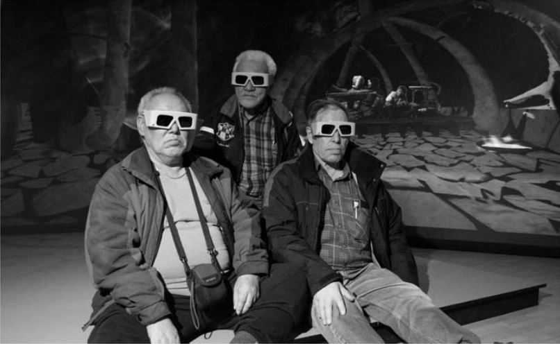
The Dawson, Levy, and Lyons article spoke about these 3D worlds having a sense of presence. Especially when these virtual worlds show a place that may have existed in the youth of an elder. This article focuses mainly on the repatriation of cultural and ancestral knowledge through replicas and the rendering of 3D/virtual experiences. In my last blog I spoke at length about the idea of digital repatriation, it is a ‘half-option’ that many Indigenous communities are exploring while they wait to set up their own collections facilities. But what was interesting about this article was that it focuses not just on the viewing of artifacts or ancestral environments rendered in virtual spaces, but transporting the viewer directly into that world. What was interesting was the idea of creating the same experience that was created for the Inuit but from the perspective of settler Europeans. This at first made me uneasy, but it was to see what types of creative licence Europeans took while describing Innu life to their people.
I loved the photograph of the Inuit elders wearing their 3D glasses, and the responses from them on seeing their traditional whalebone dwellings made me interested in seeing the further uses for this virtual technology in Indigenous capacities.
I would love to one day have a virtual tour made for Indigenous youth. It would look at the art museums of the world, maybe have a few on popular ‘wonders of the world’. It wouldn’t be reclaiming knowledge, it would be bringing those experiences from elsewhere. We are not often given the opportunities for travel and this could make a big difference in the life of someone who has only seen their fly-in community or maybe Winnipeg when going to a doctors appointment. Although there is the physical aspect missing from these mediums, it does have the ability to make meaningful connections and create lasting experiences. Although the upkeep, maintenance, and access to reliable internet infrastructures will keep current Indigenous communities from utilizing and accessing this technology. I hope that future interactions of this tech will become more portable and cost-effective for everyone to use.